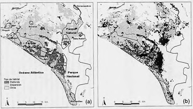
Study area map showing (a) three main habitat types (preferred, dispersal and others), the National and Natural Park limits, and nuclei where there were radio-tracked resident lynx between 1984 and 2001, and (b) the radio-locations of all dispersing lynx between 1984 and 2001. Preferred habitats mainly included Mediterranean shrubland; dispersal habitats included pine and eucalyptus plantations; and others include crops, and open habitats such as marsh, dunes, pasturelands and grassland (see Palomares et al. 2000 for a justification of the classification).
Mapa del área de estudio mostrando (a) tres tipos de hábitat principales (preferidos, de dispersión, y otros), los límites de los Parques Nacional y Natural de Doñana, y los núcleos donde ha habido linces residentes seguidos con radio-emisores desde 1984 hasta el 2001, y (b) las localizationes de todos los individuos en dispersión entre 1984 y 2001. Los hábitats preferidos incluyen formaciones de matorral mediterráneo principalmente, los de dispersión plantaciones de pinos y eucaliptos, y otras incluye cultivos, y hábitats abiertos como marisma, dunas, dehesas, y praderas (ver Palomares y col. 2000 para una justificación de la clasificación).
Source:
Palomares, F., Delibes, M., Ferreras, P., Aldama, J. J., Revilla, E., Calzada, J., and Fernandez, N. 2003. Estructura de la metapoblación de linces de Doñana. In In Memoriam al Prof. Dr. Isidoro Ruíz Martínez: 505-526. Perez Jimenez, J. M.(Ed.). Universidad de Jaén, Jaén.
